Choosing the right GPS for snowmobile trails can boost safety, planning, and trail enjoyment. This guide highlights rugged, glove-friendly navigators with topo maps, public and private land data, and snow-focused trail content. Each option below is designed to perform in extreme cold, wet conditions, and off-road environments. Read on to compare features, durability, and map content relevant to U.S. and Canadian snow trails.
Summary of Selected Products
The table below lists five GPS models optimized for snowmobile use, including display size, ruggedness, and core mapping features.
| Product | Brand | Display | Key Mapping & Terrain Features | Durability Notes |
|---|---|---|---|---|
| Garmin Tread 2 Powersport Navigator | Garmin | 6″ | OpenStreetMap trail navigation, US Forest Service MVUM, HD elevation maps | IP67, extreme temperatures |
| Garmin Tread Powersport Off-Road Navigator | Garmin | 5.5″ | Topographic maps, land boundaries, MVUM, BirdsEye imagery | IPX7, rugged |
| Garmin 7-Inch RV 795 GPS | Garmin | 7″ | North America map coverage, RV routing, POIs | Remote control option |
| Garmin eTrex 22x | Garmin | 2.2″ | Topo Active maps, routable roads/trails | Rugged handheld |
| Garmin zūmo XT | Garmin | 5.5″ | Off-road topographic maps, BirdsEye imagery, on-road maps | Ultrabright, rugged |
Note: Each product varies in screen size, mapping depth, and vehicle mounting options. Consider your snowmobile setup, glove usability, and the level of topographic detail you need for backcountry trails.
Garmin Tread 2 Powersport Navigator

The Garmin Tread 2 Powersport Navigator is a 6-inch glove-friendly touchscreen designed for extreme weather. It carries an IP67 water rating and offers turn-by-turn trail navigation with OpenStreetMap data, U.S. Forest Service MVUMs, and Adventure Roads and Trails content. High-definition elevation maps and land information help riders plan routes that include snow trails, private and public lands, campgrounds, and on-road connections with City Navigator maps for linked travel.
Key strengths include a rugged form factor suitable for winter usage, a bright display visible in direct sun or snow glare, and reliable trail content that emphasizes off-road snow routes. This model is especially useful for riders who want integrated on-trail navigation with detailed elevation data and land boundaries in both the United States and Canada.
Garmin Tread Powersport Off-Road Navigator

This rugged, weather-resistant navigator features a 5.5-inch glove-friendly, ultrabright touchscreen. It ships with preloaded topographic maps of North and Central America and street maps, plus U.S. public and private land boundaries and MVUMs. It also includes BirdsEye Satellite Imagery for high-detail views, and a powered mount with a wiring harness for secure, straightforward installation on powersport vehicles.
The device excels for snowmobilers who require detailed terrain awareness and offline map access. The included topographic data supports route planning across snow trails, with land ownership information that can help in remote backcountry tours where trail access may vary seasonally.
Garmin 7-Inch RV 795 GPS Navigator

The Garmin RV 795 offers a larger 7-inch display with North American coverage, including the U.S., Canada, and Mexico, plus Puerto Rico and other territories. It supports RV-specific routing, considering the size and weight of your vehicle, and provides a preloaded directory of RV parks and services, traveler content, and points of interest. Its screen and interface are designed for ease of use on the road, with compatibility for hands-free operation via voice and device pairing.
For snowmobilers who occasionally trailer their machines across long distances, the 795’s combination of on-road and off-road awareness makes it a versatile choice. While primarily aimed at RV users, its map depth and POI coverage can help coordinate snowmobile-accessible staging areas and nearby services along longer journeys.
Garmin eTrex 22x Rugged Handheld

The eTrex 22x is a compact handheld GPS with a 2.2-inch display and robust build for winter environments. It ships with Topo Active maps that include routable roads and trails suitable for cycling and hiking, making it a good backup or companion device for snowmobile trips. Its portability and long battery life in a rugged shell appeal to riders who want a secondary navigation option or a simple, reliable device for scouting trailheads before heading out on the snow.
While smaller than vehicle-mounted units, the 22x excels in reliability and battery efficiency. It is ideal for riders who want a lightweight backup navigator that still provides useful topo data and straightforward wayfinding on and around snow trails.
Garmin zūmo XT All-Terrain Navigator
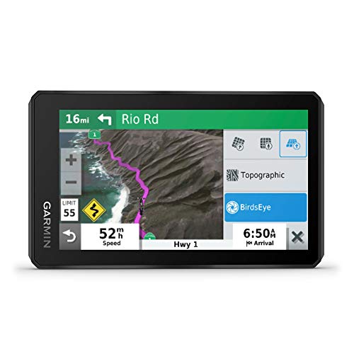
The zūmo XT is built for all-terrain use with a 5.5-inch ultrabright display and rugged construction. It supports spoken turn-by-turn directions, preloaded off-road topographic maps with public land boundaries, and BirdsEye Satellite Imagery. The device also integrates direct-to-device downloads for satellite imagery, including 4×4 roads and more, with on-road maps available for mixed use.
For snowmobile enthusiasts, the zūmo XT provides a balance of street navigation and off-road capability, ensuring you stay oriented when trails intersect roads or when detours are necessary. The waterproof, glove-friendly interface helps maintain control in winter conditions.
Garmin dēzl OTR1010 10-Inch Truck Navigator
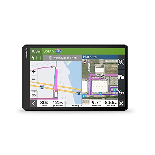
The dēzl OTR1010 offers a large 10-inch touchscreen designed for truck routing with high-resolution Birdseye imagery. It includes custom routing based on vehicle size and weight, with warnings for bridges, weight limits, and sharp grades. While aimed at trucking, its mapping depth and large display can be convenient for planning snowmobile trips that involve long highway segments and complex route options. It also provides a directory of truck and trailer services that may overlap with snowmobile accessory facilities along travel routes.
Overall, this model is best viewed as a high-visibility planning tool for long journeys that transition from highway to snowy backcountry, where clear route guidance and real-time considerations matter.
Buying Guide: Key Purchase Considerations
When selecting a GPS for snowmobile trails, consider display visibility in snow glare, glove usability, and weather sealing. Map content matters greatly for winter travel—prioritize devices with topographic details, MVUMs, BirdsEye imagery, and reliable off-road data. Connectivity options, battery life, and mounting versatility influence long trips and remote trailheads. Evaluate whether you need on-road routing alongside off-road trail navigation, as well as potential subscription-free imagery or offline map access. Finally, align your choice with your usual travel style—from compact handhelds to larger vehicle-mounted navigators—and the typical terrain you explore, including backcountry snow trails and cross-border routes.
Durability and water resistance are crucial. IP67/IPX7 ratings indicate strong protection against immersion and weather exposure. A rugged design with glove-friendly interfaces helps maintain control in cold conditions. For snowmobile use, prioritize devices with detailed topographic maps, land ownership boundaries, and MVUM data to understand trail access and private properties along routes. Consider a device with a stable mounting system and reliable power options for extended adventures through remote snowfields.
Finally, map content quality should match your trails. BirdsEye imagery and high-elevation topo maps support route planning and terrain awareness, while preloaded regional maps ensure you can navigate even when signal is limited. Subscriptions may add value for ongoing imagery updates, but many models provide substantial offline data right out of the box.
Add a Comment